To view the original visualisations in Thai, visit WorkpointToday.
Wildfire adversely affects many people in numerous aspects. The PM2.5 haze produced partly from wildfire causes severe health issues, especially for the Thais who reside in the northern part of the country, according to the highest mortality rate from Chronic Obstructive Pulmonary Disease compared to other regions’ rate.
Moreover, compared to other types of land use, the amount of fire occurs the most in forest areas; therefore, the wildfire crisis is a critical issue that should be resolved as soon as possible. This problem, however, is more intricate than it appears. To tackle the crisis efficiently, we have to start by understanding the characteristics of areas where these fires occur since these fires require different protocols to handle and there are different entities responsible for these areas.
Punch Up and Today invite you to explore the story of the wildfire crisis in northern Thailand from different angles, including the connection between fire and haze, the types of land use where fire occurs, and government agencies that should play vital roles in coping with this crisis by reading data story “Ponder Your Comprehension of the Northern Wildfire Crisis” consisting of data visualization, interactive map, photojournalism, etc. This project is a part of Demystifying the Flames, a series of news stories collaboratively produced by #PunchUp, #Today, #BangkokTribune, and #Greennews, powered by the Southeast Asia Rainforest Journalism Fund initiative of the Pulitzer Center.
Explore the data story “Ponder Your Comprehension of the Northern Wildfire Crisis” here and the stories from Demystifying the Flames here.

As a nonprofit journalism organization, we depend on your support to fund journalism covering underreported issues around the world. Donate any amount today to become a Pulitzer Center Champion and receive exclusive benefits!
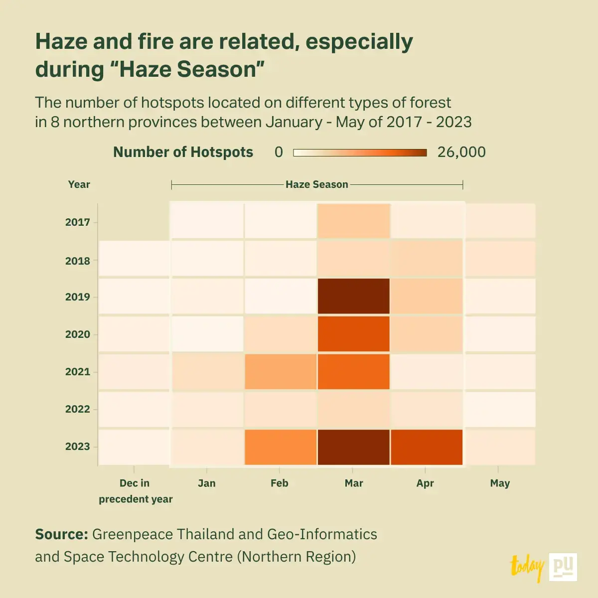
Haze and fire are connected, especially during “Haze Season”
Haze pollution is a problem Thailand has faced for a long time and does not tend to be resolved shortly. This crisis usually happens during the same period of every year that has been called “Haze Season” or from January to April. This interval is a transition between winter and summer where the air is dry and has high atmospheric pressure causing particulate matter like PM 2.5 to be suppressed and circulated near the ground level.
One of the chief causes of haze is fire, and to understand this phenomenon, scientists study this issue by detecting and analyzing Hotspots.
According to hotspot data collected by Greenpeace Thailand and Geo-Informatics and Space Technology Centre (Northern Region), in 2017 - 2023, the number of hotspots starts increasing significantly in January of every year and declines in May as the haze season passes.
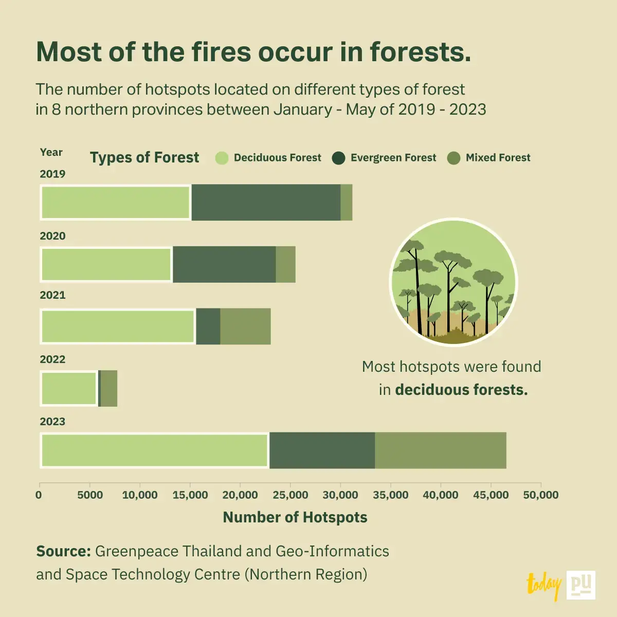
Most of the fires occur in forests.
To come up with a practical solution, we have to identify the types of land use these fires have occurred.
In 2017 - 2023, the highest number of hotspots, 80.22%, was found in the forest area.
In addition, if we classify forests into three types which are deciduous, evergreen, and mixed forest, it will appear that 54.6% of all hotspots were found in deciduous forests, while 28.73% occur in evergreen forests.
Dr. Kobsak Wanthongchai, dean of the Faculty of Forestry at Kasetsart University, explains that wildfire is a natural mechanic that helps sufficiently produce essential nutrients in the soil for trees to absorb in deciduous forest; nonetheless, the fire has to occur under suitable amounts otherwise it can deteriorate the forest. On the other hand, the evergreen forest is highly susceptible to the severity of the fire. It can be extremely hard to rehabilitate from burn damage, so evergreen forest is the area that should be protected from fire utterly.
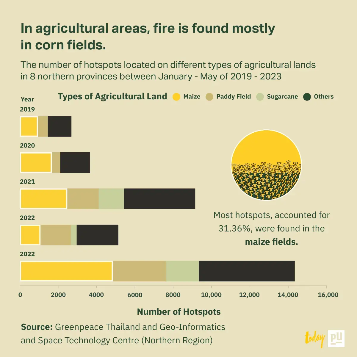
In agricultural areas, fire is found mostly in corn fields.
Besides the forests, hotspots occurring in plantation areas are also significant.
If we focus on agricultural areas categorized by the types of plant which are corn, rice, sugarcane, and others, we will find that the highest number of hotspots, 31.36%, was found in the corn fields, and the second highest, 20.04%, was found in paddy field.
Moreover, if we consider each year, we will see that the corn field is the area where the highest number of hotspots are found every year implying that the corn field is the type of plantation that should be most wary of from fire.
The reports from Greenpeace Thailand also indicate that the expansion of corn fields has huge consequences on forest areas. From 2002 - 2022, 1.9 rai of forest area was transformed into corn fields.
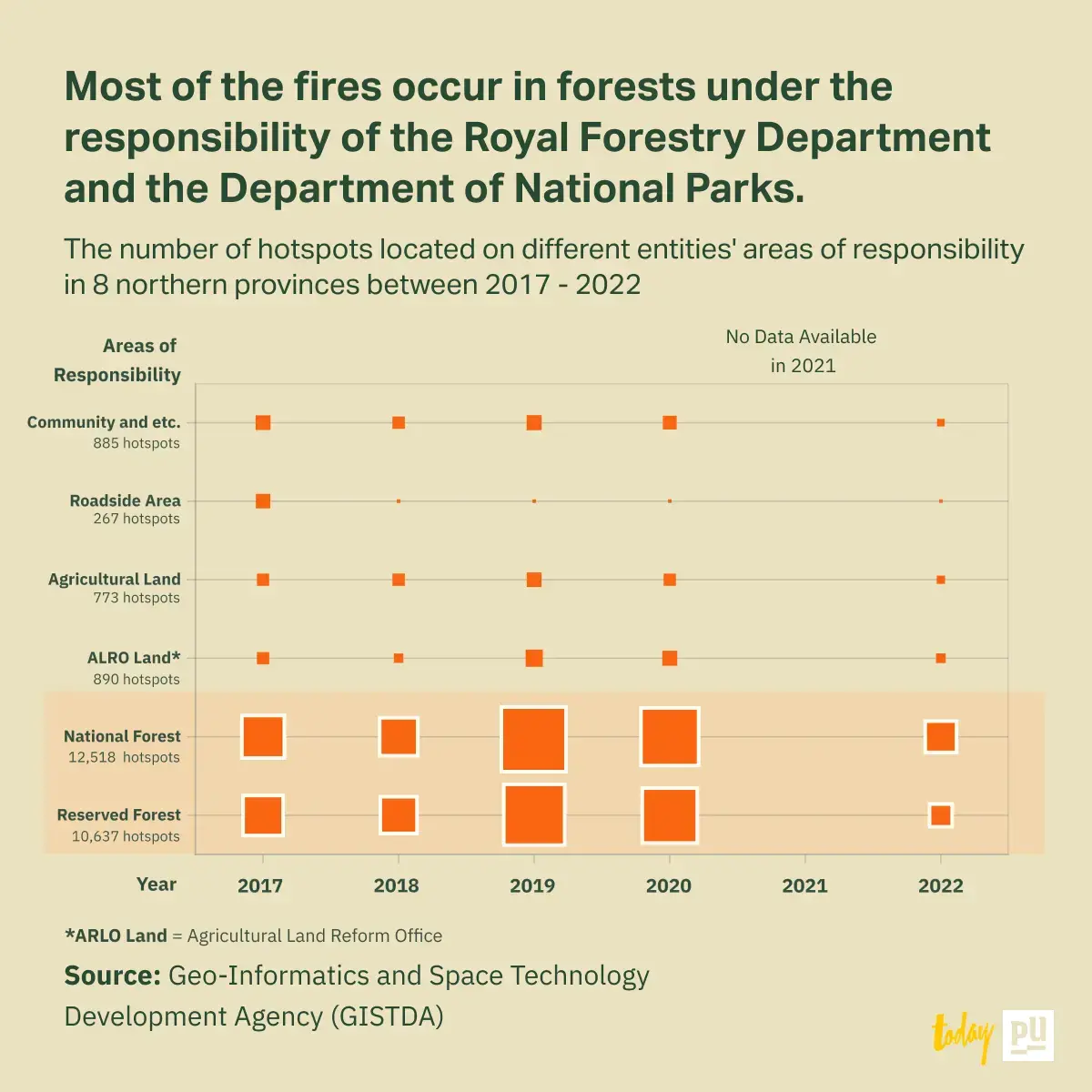
Most of the fires occur in forests under the responsibility of the Royal Forestry Department and the Department of National Parks.
The unavoidable question probably is “How can we handle this wildfire crisis?” To answer, we may have to look into the entities that are responsible for the areas where fire occurs.
According to the data, the highest number of hotspots, 12,518 spots, was found in the Reserved Forest, while 10,637 and 890 spots were found in the National Forest and the Reformed Agricultural Land respectively.
All in all, the government agencies who are responsible for these areas which are the Royal Forestry Department, the Department of National Parks, and the Agricultural Land Reform Office should be the first responders in handling this issue by being aware of the disparity between fires occurring in various types of land use.


