


Yao-Hua Law investigates the apparent gap between Peninsular Malaysia’s officially reported forest...

Analyses of environmental impact assessment reports shed light on projects that have been approved inside forests. In Part 2 of 2, come explore the projects on an interactive map. (Read Part 1 here.)
IN PENINSULAR Malaysia, land is a valuable resource. It is especially so for state governments because land and forests are the few assets that they have full authority over. Top forested states like Pahang and Kelantan derive up to a quarter of their government revenue from forestry premiums and royalties alone.
Inevitably, natural forests have given way to development. Rapid population and economic growth have trimmed forest cover in the peninsula from above 70% in the 1960s to about 45% in 2001, according to government statistics. Since then, forest loss has moderated but not stopped.
But forests offer more than just resources to extract or a site to build on. Healthy forests regulate climate, prevent floods, replenish rivers, harbour wildlife, and rein in diseases. Forests are also home – physically and culturally – to Orang Asli.

Whistleblowers and others in possession of sensitive information of public concern can now securely and confidentially share tips, documents, and data with the Pulitzer Center’s Rainforest Investigations Network (RIN), its editors, and journalists.
Projects within forests must first be approved by the state exco, particularly the state Menteri Besar or Chief Minister who almost always oversees natural resources and economic matters. Their approval suggests that they have deemed these projects benefit state and societies more than the forests could.
What then are the projects inside forests?
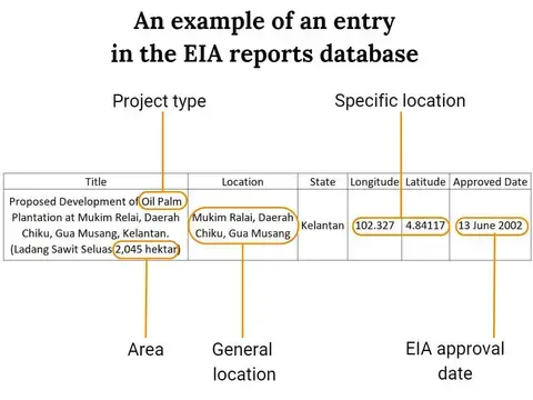
To get at the answer, Macaranga analysed a selected list of 705 environmental impact assessment (EIA) reports.
All projects that clear forests larger than 50 ha must have an EIA report passed by the Department of Environment (DOE). Getting this green-light is a huge undertaking and is almost always the last hurdle before a project can start, loggers and planters told Macaranga.
Therefore, we deduce that a reliable way to ascertain the projects that clear forests is to examine the ones whose EIA reports have been approved by the DOE.
Our findings are neither exhaustive nor conclusive. Our analyses were hampered by limited and inaccurate data in the EIA reports, particularly in terms of project locations. Source data and important caveats in the analyses are explained in the data notes at the end of this article. We encourage readers to explore the data and the map below.
Projects inside forests
Macaranga had asked the federal DOE for a complete list of approved projects but received no reply. However, EIA datasets are available on DOE’s public geospatial server. We were given a list of 9,012 EIA reports downloaded from the server by a source who requested anonymity.
This dataset contains project titles, locations, approved dates, and developer names, but not the reports themselves. Some report entries had incomplete information, and location data — either coordinates or descriptions — were sometimes inaccurate (e.g., projects located outside the country).
We had tried to cross-check the list against EIA reports, but most EIA reports were not available in the DOE library.
From the 9,012 entries in the dataset, we filtered them down to projects approved between 1 July 2001 and 30 June 2021 and located within a 2001 satellite-derived map of mature forests. We categorised each project (forest plantation, mines, logging, etc) based on information in its title. We ended up with 705 projects for our analyses.
We also acquired a map of forest reserves downloaded from the same DOE server. We could not date the map, but it looks similar to the one published in the Forestry Statistics Peninsular Malaysia 2020 and share some of the same outdated information. We mapped these forest reserves onto our base satellite map for this story.
View the map "Projects inside Peninsular Malaysia forests, July 2001-June 2021."
What are the projects?
Between 1 July 2001 and 30 June 2021, we calculated that projects in Peninsular Malaysia’s mature forests covered at least 291,773 ha. However, that figure is derived from only 545 (77%) of the 705 approved EIA reports in our analyses because the rest did not have area data.
We found 5 main project types: forest plantations, farms and aquaculture, logging, oil palm and rubber plantations, and mines and quarries.
The dataset contains very little area data for projects that build roads, power plants, hotels, shops and houses. Our findings therefore cannot capture the extant of such projects inside forests. We group these projects under the category “Others”.
Among the states, Kelantan and Pahang were where the largest number of projects inside forests were approved: 519 or 74%.
Forest plantations emerge as the primary driver of forest clearing activities. They are the most numerous (59%) and occupy 192,619 ha, or 66% of the total area of the projects. Again, Kelantan and Pahang topped the states for forest plantations. About 90% of the peninsula’s forest plantations were approved there, with approvals having shot up after 2015.
Forest plantations pose immediate concerns, not least because they involve cutting huge swathes of healthy forest reserves. Macaranga had earlier revealed that as much as two-thirds of forest plantation projects have been abandoned after the developers had logged the site. Furthermore, planters are delaying their timber harvest as they struggle with escalated costs and labour shortage.
And while the National Land Council has imposed a 15-year moratorium on new forest plantations, it does not stop those already approved by state governments. Environmental NGOs have been and continue to protest against forest plantations, such as the one being considered in the Kledang Saiong forest reserve, Perak.
More data needed
We emphasise again that our analyses are constrained by limitations in data quantity and quality (see data notes below). We lack the most authoritative datasets for examining the merits of the projects that have replaced forests: the projects’ approval letters from the state governments and complete EIA reports.
Until these documents are made public, Malaysians would have to make do with patchy pictures of how our forests are being used.
Read Part 1 on how the many discrepancies in forest data affect conservation, flood management, and sustainability commitments.
References/Further Reading
-
Faculty of Science and Marine Environment, University Malaysia Terengganu, 21030 Kuala Nerus, Terengganu, Malaysia, Edlic Sathiamurthy, Shahril Abd Halim, Luqman Md Supar, Aliya Atika Asyikin Abd. Hamid, Yee Hui Kong, and Nurul Syamimi Pauzi. 2019. “Kelantan Central Basin Flood, December 2014: Causes and Extend.” Bulletin of the Geological Society of Malaysia 68 (December): 57–67. https://doi.org/10.7186/bgsm68201905.
-
Friess, D. A., and E. L. Webb. 2011. “Bad Data Equals Bad Policy: How to Trust Estimates of Ecosystem Loss When There Is so Much Uncertainty?” Environmental Conservation 38 (1): 1–5. https://doi.org/10.1017/S0376892911000026.
-
Hansen, M. C., P. V. Potapov, R. Moore, M. Hancher, S. A. Turubanova, A. Tyukavina, D. Thau, et al. 2013. “High-Resolution Global Maps of 21st-Century Forest Cover Change.” Science 342 (6160): 850–53. https://doi.org/10.1126/science.1244693.
-
SIRIM Qas International Sdn Bhd. 2018. Public summary of MTCS audit of Pahang FMU
-
SIRIM Qas International Sdn Bhd. 2020. Public summary of MTCS audit of Pahang FMU
-
SIRIM Qas International Sdn Bhd. 2021. Public summary of MTCS audit of Pahang FMU
-
Saadatkhah, Nader, Mohammadreza Hadad Tehrani, Shattri Mansor, Zailani Khuzaimah, Azman Kassim, and Reza Saadatkhah. 2016. “Impact Assessment of Land Cover Changes on the Runoff Changes on the Extreme Flood Events in the Kelantan River Basin.” Arabian Journal of Geosciences 9 (17): 687. https://doi.org/10.1007/s12517-016-2716-z.
-
Tan-Soo, Jie-Sheng, Norliyana Adnan, Ismariah Ahmad, Subhrendu K. Pattanayak, and Jeffrey R. Vincent. 2016. “Econometric Evidence on Forest Ecosystem Services: Deforestation and Flooding in Malaysia.” Environmental and Resource Economics 63 (1): 25–44. https://doi.org/10.1007/s10640-014-9834-4.
-
Turubanova, Svetlana, Peter V Potapov, Alexandra Tyukavina, and Matthew C Hansen. 2018. “Ongoing Primary Forest Loss in Brazil, Democratic Republic of the Congo, and Indonesia.” Environmental Research Letters 13 (7): 074028. https://doi.org/10.1088/1748-9326/aacd1c.
-
Yahaya, Nurul Syazwani, Choun-Sian Lim, Umi Amira Jamaluddin, and Joy Jacqueline Pereira. 2015. “The December 2014 Flood in Kelantan: A Post-Event Perspective” 41 (3).
-
Sahabat Alam Malaysia. 2020. "Statistical data on forested and conservation areas in Malaysia".
Notes on Data Analyses
Details of how we collected and analysed the data for this series can be found here.