Project
Welcome to the Anthropocene
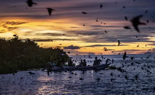
Inhabitants of the Bailique Islands in the Amazon delta of Brazil in the state of Amapá have adapted...
In north Brazil, the combined effects of a hydroelectric dam and earth-shifting livestock have altered the landscape — and upended peoples’ lives.
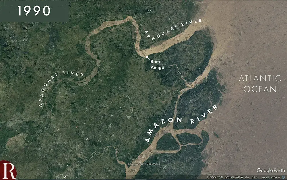
Jaime Lucian dos Santos Filho was born and raised in a stilt house on the Araguari River, in the north Brazil village of Bom Amigo. His family and the several dozen other inhabitants of the town ate fish from the Araguari, ranched buffalo on its banks, and watered subsistence gardens with it. When they went shopping, they took a boat.
In flood season the Araguari became a mighty torrent, more than two miles across. The rest of the year it just flowed along. That started to change in the early 2000s, when Filho noticed the river’s current slackening. Sand bars began to appear off the town’s docks, and then gradually grew. By 2013 the riverbed of the Araguari — all the way to its mouth at the Atlantic, 12 miles away — had filled with silt, and the river no longer flowed past Bom Amigo.
Filho says extra land appeared, but it was a mixed blessing. “The fields opened up for cattle. There are some more land for us to plant. But the water became scarcer.”

As a nonprofit journalism organization, we depend on your support to fund more than 170 reporting projects every year on critical global and local issues. Donate any amount today to become a Pulitzer Center Champion and receive exclusive benefits!
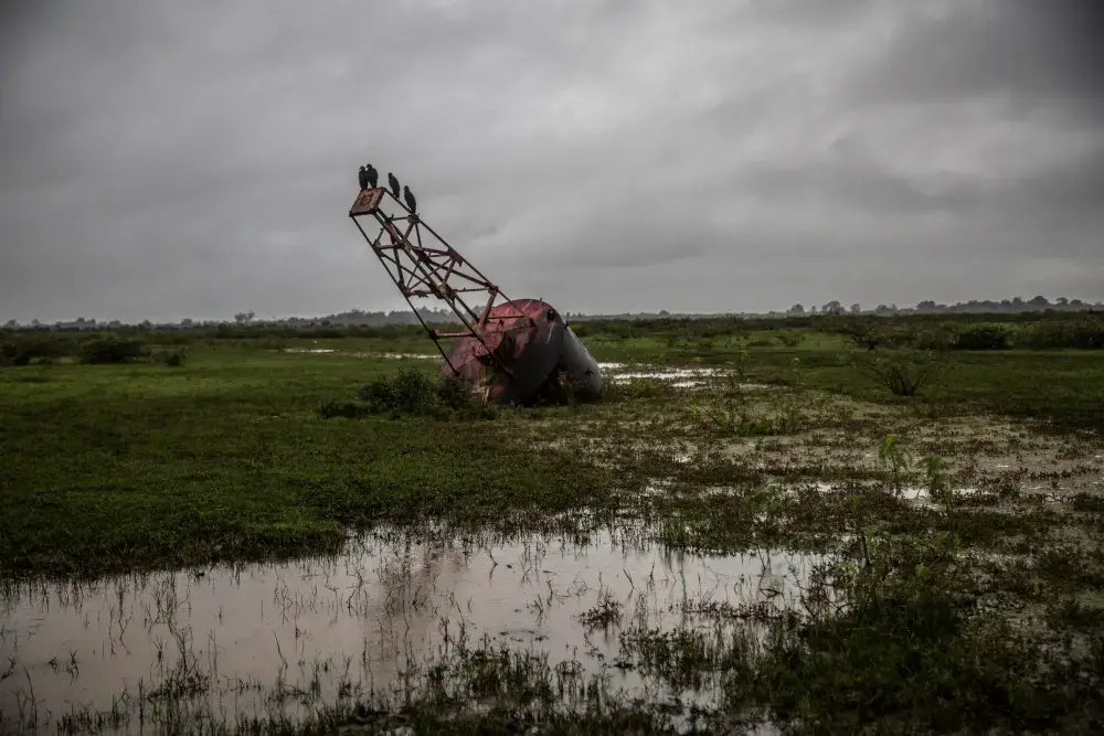
Today, miles of the Araguari’s old bed flood for a few rainy months. They turn dry and stone-hard the rest of the year.
Robbed of the reason for the town’s existence, residents moved away.
Fihlo’s daughter-in-law, Joselina Barbosa Tavares, said, “I never imagined that a mighty river like that could ever dry.”
At about the same time, villagers 20 miles away in a town called Junco were uprooted by a different river’s transformation. In that case they were inundated with water, not deprived of it.
In 2012 Domingo Maciel da Costa was hired to guard a water buffalo ranch just east of Junco, on the north branch of the Amazon. A small river called the Urucurituba Channel ran through the land.
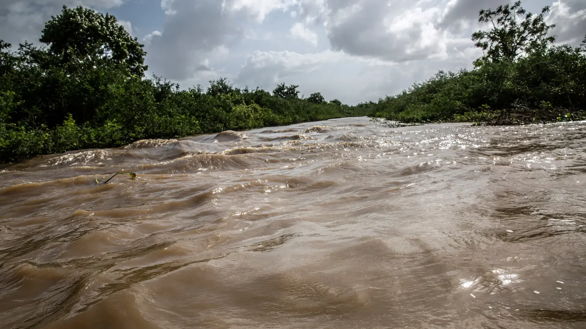
The Urucurituba has changed dramatically during da Costa’s life. In the mid 1990s, before it even had an official name, it was about 200 feet across and ran only a few miles from its headwaters in a palm jungle to its mouth, where it emptied into the Amazon. After that it started metastasizing. By the time da Costa took the ranching job, the river was a quarter of a mile from shore to shore and 25 miles long.
And it kept growing. On some days it grew half a dozen feet wider.
Sitting in a boat bobbing in the Urucurituba, half a mile from the nearest land, and recalling his years at the ranch, da Costa waves his hand around. “In a short time, it became this monster you see here,” he says.
He was floating on top of where he used to work, which had long ago been swallowed up by the river. “This is where our house, our pasture, our land, stood,” he says, looking into the water.
Where did this monster come from? Brazilian scientists studying the Araguari River and the Urucurituba Channel have concluded that the silting up of the former and the ongoing expansion of the latter are flip sides of the same coin, caused by the same process: the combined consequence of a hydroelectric dam built far up the Araguari and the introduction of water buffalo into its flood plain.
James Leonard Best, a geology professor at the University of Illinois Urbana-Champaign, says he’s startled by the rapidity of the Urucurituba and Araguari’s metamorphoses. Still, he expects more surprises such as these in the future, as human encroachment on the channels and shores of the world’s rivers increases. In a 2019 paper he published in the journal Nature Geoscience, he warned about extensive river-sand extraction, accelerated hydroelectric power plant construction, introduction of non-native species and other, “anthropogenic stressors.” He predicted that “large-scale, and potentially irreparable, transformations may ensue in periods of years to decades, with ecosystem collapse being possible in some big rivers.”
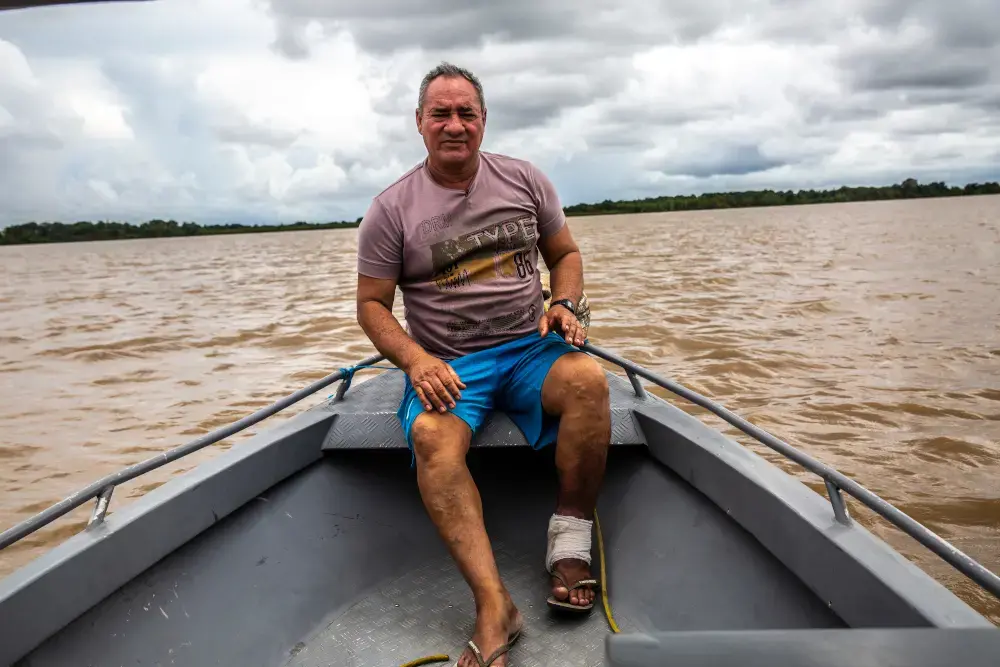
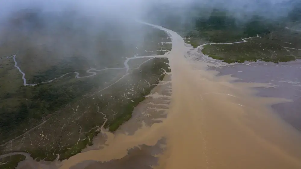
Last April I traveled with Brazilian photojournalist Dado Galdieri to see what forces blocked the Araguari and gnaw the shores of Junco. We hired a squat wooden freighter and crew in Macapá, the capital of the state of Amapá, and set off.
Twelve hours downstream of Macapá, Marlon Pantoja Cardoso, our captain, steered into the north fork of the Amazon. Right past Junco we entered a gap in the shore that looked to me like a broad bay burrowing into the jungle. Cardoso said this was the mouth of the Urucurituba Channel, nearly a mile across. He’d heard that the blockage of the Araguari’s mouth caused the Urucurituba to swell, and it made sense to him.
“The water had to go somewhere, and it came here,” he said.
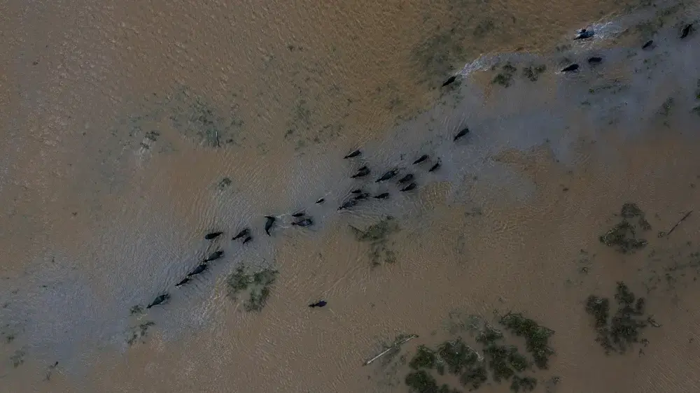
We headed up the Urucurituba. Where the forest had once stood, broad wetlands flanked the river’s deep channel. A flock of scarlet ibis, startled by our motor’s throaty roar, took flight in a shimmering cloud of neon orange. Water buffalo chewed water hyacinth and eyed us warily. Some of them trudged in small groups snout-to-tail through the muck.
Before leaving Macapá, I’d heard that these listless creatures — an Asian species introduced to Brazil in the 19th century — had broken down the shallow divide that had kept the Araguari and Amazon basins separate and created the Urucurituba’s Niagara-Falls-scale flow.
Alan Cunha, a professor of civil engineering at the Federal University of Amapá, explained how this had happened.
Cunha has been studying the Araguari for decades. He said the buffalo were one of two powerful forces that together stoppered the lower Araguari and opened the Urucurituba.
The Amazon and Araguari rivers occupy adjacent flood plains. Until about the early 2000s, a feeble berm a few feet high kept the rivers apart in separate basins, the former originating in the Andes and the latter in a range called the Tumucumaque mountains.
The base of these flood plains is geologically young, made of sediment too recently deposited to have solidified — or, in geologists’ terms, “consolidated.” So, Cunha said, the natural berm is “extremely fragile and vulnerable” and easy to disturb.
Encouraged by subsidies from Brazil’s military government in the 1980s, ranchers began setting water buffalo lose to graze in this region. Nobody predicted how much mischief they’d cause. About 200,000 buffalo now wander freely there. The ones we saw from the boat demonstrated why ranchers prize them: The livestock happily wade in the marshes and shallow streams. Compared to cattle, they swim better and eat more kinds of grass.
Cunha says one behavior has made water buffalo particularly damaging to the divide between the Amazon and the Araguari. He says that they march in troop-like single file, gouging trenches in soil.
In the decades after buffalo were introduced, their relentless hooves turned natural creeks that fill and drain with each tidal cycle into a dendritic network of waterways that extended the embryonic Urucurituba. Then, sometime in the late 2000s, the incessant stomping, compounded by ranchers’ forest-clearing and ditch-digging, broke open a path between the Urucurituba and the Araguari. The two rivers became linked, and the Araguari’s flow started running through the Urucurituba into the Amazon.
Cunha was the first scientist to report that the Urucurituba was draining the Araguari. In 2012, he took a speedboat from the upper Araguari toward the Atlantic. Near the mouth, he noticed shoals where he expected deep water. The current was far lower there than it had been where he’d started, a finding that puzzled him. River discharge generally increases downriver, with contributions from tributaries.
“How is that possible,” he thought. “Where is the water going?”
He retraced his route back upstream, looking for a missing branch draining the river. Forty-five miles from the mouth, he noticed what seemed at first like a small creek breaking away. He tied a device for measuring the current to a tree. A week later he returned to get the data. But the device was gone. So was the tree. Both had been carried off when a big hunk of shoreline slipped into the mysterious river.
“That’s when we started connecting the dots,” Cunha says. He’d discovered the headwaters of the Urucurituba Channel. And it was on its way to draining the Araguari’s full current.
He discovered that the Urucurituba was growing wider at breakneck speed. Between late 2011 and mid-2016 it widened an average of 16 feet every month. Soon it had become as wide and deep, and half as long, as the Panama Canal. The Araguari’s entire current was going through the Urucurituba to the Amazon.
“It was a huge surprise,” Cunha says. In scientific terms, the Amazon had “captured” the Araguari.
Grazing buffalo kicked, and their ditch-digging ranchers opened, the natural dike separating the Amazon and Araguari basins. But Cunha says the animals and their keepers didn’t silt up the lower Araguari and open the Urucurituba all by themselves. They got help from the Coaracy Nunes power plant, the first of three large hydroelectric installations built on the Araguari.
Valdenira Santos, a geologist at the Institute of Scientific and Technological Research in Macapá, says the builders of the dams “did not consider the downstream effect the hydroelectrical plants would cause.” Santos wrote her graduate dissertation on the Araguari. The flow of water just upstream of the Araguari’s power plants, she says, varies greatly between rainy and dry seasons. Reservoirs built for each of these plants smooth out these variations, stabilizing power production. But suppressing natural extremes in river flow also altered the movement of sediment near the river’s mouth.
One day soon after our excursion up the Urucurituba, Galdieri and I sat in a speedboat mid-river in the Amazon’s north channel. Railan Souza, the boat’s pilot, scanned the line where the river met the sky. We were on a mission to see one of the region’s natural wonders, which also plays a role in explaining changes in the region’s plumbing.
A wave sprinted toward us, rising higher and cresting in a line of white spray. It was the tidal bore, known in Brazil as the pororoca, a train of waves that race up Amazon twice a day. When the moon is full, as it had been the previous night, the waves are biggest. The frothing torrent soon licked at our prop. It must have been at least six feet high. Souza cast a nervous glance behind us, first gunning the engine, then slowing down to let the wave lift us up. Hooting with joy, he matched our speed to it, perching us atop the wall of water. The crest’s alabaster color belied the contents of the liquid. Tidal bores bear incredible amounts of sediment mixed into their convulsions, sometimes 50 times as much silt as smoothly moving water.
Every year the Amazon discharges half a billion tons of silt into the Atlantic, about 10 times the annual mass of sand and gravel mined in the United State. A plume of this material, easily seen from space, spreads 60 miles out to sea and up the coast, right past the Araguari’s old mouth, like coffee grounds spilled on a sheet of blue glass.
Before the Araguari got clogged, it also had pororocas. Visitors came from all over the world to surf on them. The waves also carried thousands of tons of sediment from the Amazon’s silt plume upstream and dropped it on the riverbed.
Cunha says the river’s current and ebb tides used to wash these deposits back to sea, keeping the Araguari’s channel and mouth clear. But he says the natural process of deposition and removal of sediment was upset when the Coaracy Nunes plant went online in 1976. During the dry season, when the river was already running at its slowest, powerplant operators held back water to let it accumulate in its reservoir.
There’s virtually no data about the Araguari from back then, but Cunha says it seems that when enfeebled by power plant operators, the river could no longer flush accumulated sediment out its mouth. As silt filled the Araguari’s lower reach, the river’s original bed was no longer the easiest path for the current, and so a portion of the flow drained into the Urucurituba instead. He suspects that silt released by the gradually widening Urucurituba compounded the problem. This material, suspended in the flow, was carried up the Urucurituba with tides running up from the Amazon’s mouth and then dropped into the lower Araguari. And, in a vicious cycle, this extra load blocked the river’s mouth more and coaxed even more water into the Uricurituba, eventually completely blocking the Araguari’s passage to the Atlantic.
The Urucurituba continues growing wider, flooding forests on either shore and advancing deeper into Junco. Da Costa, who first showed me the “monster,” says the town has also lost 25 acres of palms, about 14 soccer fields’ worth, that once produced lucrative açaí berries, the superfood that is among the region’s major cash crops.
Cunha says the Araguari near where the Urucurituba Channel begins is also widening. In the town of Pracúuba, a short distance upstream from that fork, many residents are in constant fear that their houses will collapse into the river. Scores of people have dismantled their homes and rebuilt them farther inland.
José Freitas, who lives near the Urucurituba, says he’s collecting construction materials for building a new house when the river gets too close. But he can’t say how he’ll afford a move.
“Everywhere we’d go there’s already an owner. And we don’t have money buy new land.”
James Best, the University of Illinois Urbana-Champaign geologist, says millions of people across the planet could soon find themselves uprooted like the residents of Junco, Bom Amigo and Pracúuba. Rivers everywhere are straining under of the combined assault of multitudes of insults — from dams to pollution to shoreline disturbance.
“These are going to impact humans living in riverine corridors big-time.”
Geologist Valdenira Santos sees the transformation of the region as a cautionary tale — and not just for people living in river basins.
“Our biggest challenge now, as planet, is to be able to coexist along these natural processes in a wiser fashion,” she says. “Human beings shouldn’t have the illusion that we can tame all of nature. It will be always stronger than us.”
 View this story on El Pais